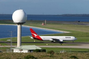
Australia’s aviation industry relies on Airservices for the provision and maintenance of air navigation technology and equipment critical to aviation safety at regional and major airports, aerodromes and airstrips. Below are a few of the critical navigation aids that controllers use every day to keep Australian skies safe.
Automatic Dependent Surveillance Broadcast
Automatic Dependent Surveillance Broadcast (ADS-B) is a surveillance technique by which an aircraft fitted with ADS-B capable transponder transmits, via data link, a series of parameters extracted from the on-board navigation and positioning systems to more than 100 ground stations all around the country. The data is then displayed on controllers’ screens and provides accurate surveillance.
Radar

Airservices uses terminal area radar (TAR) and en route radar to assist with separation of aircraft in controlled airspace. At major airports, it is common to have both radar in use.
TAR, or primary radar, relies on radio waves reflecting off metallic objects and is effective within a short range from the radar head. Regardless of whether an aircraft has a transponder, primary radar will detect an aircraft’s position, height and approximate airspeed. TARs are useful for detecting aircraft in controlled airspace close to the airports.
En route radar, or secondary surveillance radar, relies on an aircraft having a transponder which transmits a data signal. The signal is received and interrogated by a ground station. En route radar covers larger volumes of airspace ranging from 250 nm (463 km) in radius and up to 100 000 ft (30 km).
Instrument Landing Systems

An ILS is a highly accurate radio signal navigation aid used by pilots for landing at an airport when there is poor weather or low visibility.
An ILS consists of two antenna systems which transmit signals to receivers in the aircraft cockpit — a glide path tower located next to the runway, and a localiser installed at the end of the approaching runway. These antenna systems provide a pilot with vertical and horizontal guidance when landing.
Advanced Surface Movement Guidance and Control System
Advance Surface Movement Guidance and Control System (A-SMGCS) works in a similar way to ADS-B but on the ground. It uses many distributed Radio Frequency sensors and Surface Movement Radar to detect vehicles and aircrafts on the airport surface. Aircraft and ground vehicles are fitted with a transponder which transmits a signal to a receiver at the airport. Used at major airports, A-SMGCS shows the position of aircraft and ground vehicles on a screen in front of the surface movement controller in the tower.
Wide Area Multilateration
Wide Area Multilateration (WAM) is a Surveillance technique that uses Time Difference of Arrival (TDOA) of signals from a target object (like an aircraft) to multiple receivers to calculate its position.
SY WAM system provides surveillance data for Precision Runway Monitor (PRM) operations (required for conducting simultaneous, independent approaches to closely spaced, parallel runways, identified as PRM approaches) in Sydney. It also supplements Radar and ADS-B coverage in the Sydney basin for the enroute sectors.
TAS WAM system provides the sole source of surveillance in the Tasmanian Airspace. This includes a Radar-like output along with ADS-B.
Ground Based Augmentation System
A Ground-Based Augmentation System (GBAS) is a landing system that utilises the Global Navigation Satellite System (GNSS). A GBAS consists of ground-based hardware and software that augments GPS signals to provide the required integrity, continuity, accuracy and availability to support a precision approach. A single GBAS installation at an airport can provide a precision approach to multiple runways simultaneously.
Smart Tracking
Smart Tracking is a form of performance-based navigation using satellite technology to precisely plot an aircraft’s flight through a specific three-dimensional path in the sky. Smart Tracking use can reduce flying time for passengers, fuel use and CO2 emissions.
Non-Directional Beacon (NDB)
The NDB radiates an omni-directional signal from which suitably equipped aircraft can determine the direction to the beacon. By following the direction indicated by the automatic direction finding (ADF) instrument the aircraft will track toward the NDB.
Very High Frequency (VHF) Omni-Range (VOR)
The VHF Omni-Range is a course-forming aid providing bearing (azimuth) information to suitably equipped aircraft for guidance in enroute operations through to the non-precision approach procedure. The VOR enables a pilot to determine the bearing of the aircraft from a VOR beacon, and, if necessary, track to or from the beacon on a selected radial.
Distance Measuring Equipment (DME)
The DME provides slant distance between an aircraft and a ground station to suitably equipped aircraft. The DME is used in enroute and terminal operations. In a terminal environment the DME is typically associated with a VOR so that the combined functionality of the ground station becomes distance and bearing. In addition, a DME may be associated with an ILS installation where it has replaced the ILS marker beacons by providing distance to touchdown information.